![](/images/other/stat-length.png)
![Tocht Stappen Mézières (FR) - Berlens-La Neirigue - Photo](https://media.geolcdn.com/t/1900/400/ext.pjpeg?maxdim=2&url=https%3A%2F%2Fstatic1.geolcdn.com%2Fsiteimages%2Fupload%2Ffiles%2F1553511878bg_sport_marche.png)
Berlens-La Neirigue
hgauchat
Gebruiker
![Lengte](/images/other/stat-length.png)
Lengte
9,1 km
![Max. hoogte](https://static1.geolcdn.com/siteimages/upload/files/1508320355ic_sort_altitude_max_24dp.png)
Max. hoogte
864 m
![Positief hoogteverschil](https://static1.geolcdn.com/siteimages/upload/files/1508320355ic_sort_den_pos_24dp.png)
Positief hoogteverschil
211 m
![Km-Effort](/images/other/stat-length.png)
Km-Effort
11,9 km
![Min. hoogte](https://static1.geolcdn.com/siteimages/upload/files/1508320355ic_sort_altitude_min_24dp.png)
Min. hoogte
703 m
![Negatief hoogteverschil](https://static1.geolcdn.com/siteimages/upload/files/1508320355ic_sort_den_neg_24dp.png)
Negatief hoogteverschil
203 m
![Boucle](https://static1.geolcdn.com/siteimages/upload/files/16400158638029165_repeat_loop_refresh_sync_direction_icon.png)
Boucle
Neen
Datum van aanmaak :
2017-11-30 00:00:00.0
Laatste wijziging :
2017-11-30 00:00:00.0
![Stappen](https://static1.geolcdn.com/sitytour/trail-icons/101.png)
2h36
Moeilijkheid : Gemakkelijk
![Scan deze QR-code om de tocht te openen in de SityTrail-applicatie](https://capi.geolives.com/qq0zvz2zws4bq2lad0pu/sitytour/trails/245532/qr.png?size=200)
Gratisgps-wandelapplicatie
Over ons
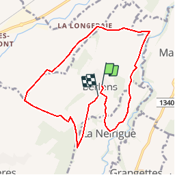
Tocht Stappen van 9,1 km beschikbaar op Fribourg/Freiburg, District de la Glâne, Mézières (FR). Deze tocht wordt voorgesteld door hgauchat.
Beschrijving
Romont-Berlens: 4km , 10min ,
Indemnité km:2.-
Parking:Sur l'esplanade des églises.
Restaurant:Auberge du Pèlerin:026/652.20.80
Curiosité:Chapelle Notre Dame de l'Epine et St. Joseph.
Plaatsbepaling
Land:
Switzerland
Regio :
Fribourg/Freiburg
Departement/Provincie :
District de la Glâne
Gemeente :
Mézières (FR)
Locatie:
Unknown
Vertrek:(Dec)
Vertrek:(UTM)
343517 ; 5173139 (32T) N.
Opmerkingen
Wandeltochten in de omgeving
![Tocht Fiets Mézières (FR) - Berlens - Photo](https://media.geolcdn.com/t/375/260/ext.jpg?maxdim=2&url=https%3A%2F%2Fservices.sitytrail.com%2FGeolivesWS%2FDownloadMedia.ashx%3FTrailID%3D873371%26Media%3D20171207151650.jpg)
![Fiets Fiets](https://static1.geolcdn.com/sitytour/trail-icons/200.png)
Berlens
Fiets
Heel gemakkelijk
Mézières (FR),
Fribourg/Freiburg,
District de la Glâne,
Switzerland
![](/images/other/stat-length.png)
8,5 km | 10,6 km-effort
2h 30min
![](https://static1.geolcdn.com/siteimages/upload/files/16400158638029165_repeat_loop_refresh_sync_direction_icon.png)
Ja
![Tocht Fiets Mézières (FR) - Berlens - Photo](https://media.geolcdn.com/t/375/260/ext.jpg?maxdim=2&url=https%3A%2F%2Fservices.sitytrail.com%2FGeolivesWS%2FDownloadMedia.ashx%3FTrailID%3D872972%26Media%3D20171207151650.jpg)
![Fiets Fiets](https://static1.geolcdn.com/sitytour/trail-icons/200.png)
Berlens
Fiets
Heel gemakkelijk
Mézières (FR),
Fribourg/Freiburg,
District de la Glâne,
Switzerland
![](/images/other/stat-length.png)
8,5 km | 10,6 km-effort
2h 30min
![](https://static1.geolcdn.com/siteimages/upload/files/16400158638029165_repeat_loop_refresh_sync_direction_icon.png)
Ja
![Tocht Fiets Mézières (FR) - Berlens - Photo](https://media.geolcdn.com/t/375/260/ext.jpg?maxdim=2&url=https%3A%2F%2Fservices.sitytrail.com%2FGeolivesWS%2FDownloadMedia.ashx%3FTrailID%3D872964%26Media%3D20171207151650.jpg)
![Fiets Fiets](https://static1.geolcdn.com/sitytour/trail-icons/200.png)
Berlens
Fiets
Heel gemakkelijk
Mézières (FR),
Fribourg/Freiburg,
District de la Glâne,
Switzerland
![](/images/other/stat-length.png)
8,5 km | 10,6 km-effort
2h 30min
![](https://static1.geolcdn.com/siteimages/upload/files/16400158638029165_repeat_loop_refresh_sync_direction_icon.png)
Ja
![Tocht Stappen Villorsonnens - Villarsiviriaux Esseiva - Photo](https://media.geolcdn.com/t/375/260/ext.jpg?maxdim=2&url=https%3A%2F%2Fstatic1.geolcdn.com%2Fsiteimages%2Fupload%2Ffiles%2F1553511878bg_sport_marche.png)
![Stappen Stappen](https://static1.geolcdn.com/sitytour/trail-icons/101.png)
Villarsiviriaux Esseiva
Stappen
Medium
Villorsonnens,
Fribourg/Freiburg,
District de la Glâne,
Switzerland
![](/images/other/stat-length.png)
9,4 km | 11,8 km-effort
2h 32min
![](https://static1.geolcdn.com/siteimages/upload/files/16400158638029165_repeat_loop_refresh_sync_direction_icon.png)
Ja
![Tocht Stappen Mézières (FR) - Berlens 07.12.2017 - Photo](https://media.geolcdn.com/t/375/260/ext.jpg?maxdim=2&url=https%3A%2F%2Fstatic1.geolcdn.com%2Fsiteimages%2Fupload%2Ffiles%2F1553511878bg_sport_marche.png)
![Stappen Stappen](https://static1.geolcdn.com/sitytour/trail-icons/101.png)
Berlens 07.12.2017
Stappen
Gemakkelijk
Mézières (FR),
Fribourg/Freiburg,
District de la Glâne,
Switzerland
![](/images/other/stat-length.png)
7,8 km | 9,9 km-effort
2h 9min
![](https://static1.geolcdn.com/siteimages/upload/files/16400158638029165_repeat_loop_refresh_sync_direction_icon.png)
Ja
![Tocht Stappen Villaz - Villaz Esseiva - Photo](https://media.geolcdn.com/t/375/260/ext.jpg?maxdim=2&url=https%3A%2F%2Fstatic1.geolcdn.com%2Fsiteimages%2Fupload%2Ffiles%2F1553511878bg_sport_marche.png)
![Stappen Stappen](https://static1.geolcdn.com/sitytour/trail-icons/101.png)
Villaz Esseiva
Stappen
Gemakkelijk
Villaz,
Fribourg/Freiburg,
District de la Glâne,
Switzerland
![](/images/other/stat-length.png)
9,6 km | 12 km-effort
2h 35min
![](https://static1.geolcdn.com/siteimages/upload/files/16400158638029165_repeat_loop_refresh_sync_direction_icon.png)
Ja
![Tocht Stappen Romont (FR) - Romont - Hennens - Prévonloup - Billens - Photo](https://media.geolcdn.com/t/375/260/ext.jpg?maxdim=2&url=https%3A%2F%2Fstatic1.geolcdn.com%2Fsiteimages%2Fupload%2Ffiles%2F1553511878bg_sport_marche.png)
![Stappen Stappen](https://static1.geolcdn.com/sitytour/trail-icons/101.png)
Romont - Hennens - Prévonloup - Billens
Stappen
Heel gemakkelijk
Romont (FR),
Fribourg/Freiburg,
District de la Glâne,
Switzerland
![](/images/other/stat-length.png)
9,8 km | 12,5 km-effort
2h 40min
![](https://static1.geolcdn.com/siteimages/upload/files/16400158638029165_repeat_loop_refresh_sync_direction_icon.png)
Ja
![Tocht Stappen Villorsonnens - Villarsiviriaux - Massonnens - Villargiroud - Villarsel-le-Gibloux - Villarlod - Photo](https://media.geolcdn.com/t/375/260/ext.jpg?maxdim=2&url=https%3A%2F%2Fstatic1.geolcdn.com%2Fsiteimages%2Fupload%2Ffiles%2F1553511878bg_sport_marche.png)
![Stappen Stappen](https://static1.geolcdn.com/sitytour/trail-icons/101.png)
Villarsiviriaux - Massonnens - Villargiroud - Villarsel-le-Gibloux - Villarlod
Stappen
Gemakkelijk
Villorsonnens,
Fribourg/Freiburg,
District de la Glâne,
Switzerland
![](/images/other/stat-length.png)
10,6 km | 13,1 km-effort
2h 50min
![](https://static1.geolcdn.com/siteimages/upload/files/16400158638029165_repeat_loop_refresh_sync_direction_icon.png)
Ja